DAVAO CITY(January 12) — Nearing its midpoint, the Samal Island–Davao City Connector (SIDC) has become a defining test of whether large-scale infrastructure can advance regional growth without degrading the marine ecosystems that sustain island communities.
The Island Garden City of Samal (Igacos) said construction has reached 46.47 percent, with the Department of Public Works and Highways (DPWH) standing by its target 2028 opening.
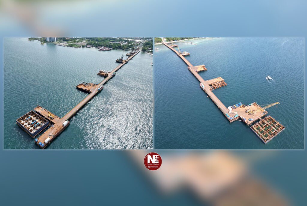
A bridge built for regional growth
The 3.9-kilometer, four-lane cable-stayed bridge will connect Barangay Limao in Samal Island to the R. Castillo–Daang Maharlika junction in Davao City, cutting travel time from 30–55 minutes by ferry to about five minutes. Officials say the bridge will integrate Samal more closely into Davao City’s economy, boosting tourism, trade, and labor mobility.
Yet below the construction corridor lies the Pakiputan Strait, a narrow but biologically productive waterway where fisheries and tourism depend heavily on healthy coral reefs.
“If the corals go, the fish go”
For fisherfolk along the strait, environmental risks are immediate and personal.
“If the corals are damaged, the fish disappear,” said Ramon, a fisherman from Barangay Limao with over 20 years at sea. “We are not against development. But this water feeds our families.”
Fishers say they have noticed occasional declines in catch during periods of heavy marine activity linked to construction support vessels, though they acknowledge that weather patterns and seasonal variability also affect daily harvests.
What the data show
Environmental groups point to long-term trends to explain these fears.
Based on assessments by marine scientists and local conservation offices, reef cover in parts of the Pakiputan Strait has declined over the past two decades, with some nearshore areas classified as fair to poor due to cumulative stress from coastal development, sedimentation, and overfishing.
Local fisheries monitoring groups and academic studies in Davao Gulf waters—including the Pakiputan Strait—have also documented a gradual decline in average fish catch per small-scale fisher, a trend attributed to reef degradation, increased fishing pressure, and habitat disturbance.
While no single project is blamed for these changes, marine experts warn that additional stress in already pressured reef systems can push them past recovery thresholds, particularly if mitigation measures fail.
DPWH: safeguards in place
The DPWH said it has incorporated multiple environmental safeguards into the bridge’s design and construction.
In previous briefings, DPWH officials said pile driving and marine works are being conducted under environmental compliance certificates, with measures such as controlled construction schedules, silt curtains, and continuous monitoring to limit sediment spread.
“The project is being implemented with due regard for environmental protection,” DPWH has said, stressing that the bridge’s alignment and construction methods were reviewed to balance engineering requirements and ecological concerns.
DPWH officials have also pointed to the 47-meter navigational clearance, saying it minimizes long-term disruption to marine traffic and surface water movement once construction is completed.
DENR: monitoring, not blind approval
The Department of Environment and Natural Resources (DENR), for its part, has said it is actively monitoring compliance with environmental conditions tied to the project.
DENR officials have acknowledged the ecological sensitivity of the Pakiputan Strait, particularly near Paradise Reef and the Hizon Marine Protected Area, and said any verified violations could trigger enforcement actions or corrective measures.
Environmental monitoring reports submitted to regulators, the DENR said, are meant to track coral health, water quality, and sediment levels throughout the construction period.
Tourism walks a tightrope
Resort operators, meanwhile, see both promise and peril.
“The bridge will help us logistically,” said a resort manager on Samal Island. “But tourists don’t come here for convenience alone. They come for clear water and marine life.”
He warned that even small, visible declines in reef health or water clarity could hurt Samal’s reputation as an eco-tourism destination. “Once that image is damaged, it’s very hard to rebuild.”
Timeline: the Writ of Kalikasan case
April 2025 • Coastal residents and environmental advocates file a petition for a Writ of Kalikasan, citing risks to coral reefs and marine protected areas.
May–June 2025 • Petitioners seek a Temporary Environmental Protection Order (TEPO) to halt construction.
June 2025 • The Court of Appeals of the Philippines denies the TEPO request.
July 1, 2025 • The Supreme Court of the Philippines issues a Writ of Kalikasan, ordering the DPWH, DENR, the Samal Island Protected Landscape and Seascape Protected Area Management Board, and the contractor to submit verified responses.
Present • The case remains pending, with the Court reviewing environmental safeguards and accountability rather than ordering a construction halt.
Environmental lawyer Jenny Ramos has stressed that the denial of a provisional remedy does not resolve the substantive environmental issues raised.
A narrowing window for balance
As the DavSam Bridge rises over the Pakiputan Strait, its impact will ultimately be judged not just by reduced travel times or traffic volumes, but by whether fishers can still fish, reefs can still recover, and tourism can still thrive.
For Samal and Davao, the challenge is no longer whether development will come—but whether it can arrive without costing coastal communities the natural systems that sustain them.

