DAVAO CITY (June 15) — Residents of coastal communities in Sarangani and Davao Occidental thought something was wrong when the sea appeared to move away from shore.
Two days after the powerful magnitude 7.8 earthquake that struck southern Mindanao, villagers began noticing something unusual. Areas that had always been underwater were suddenly exposed. Corals, seagrass beds, shells, and marine creatures lay stranded under the sun.
What many initially feared was a sign of another impending disaster turned out to be a dramatic geological event caused by the earthquake itself.
According to the Department of Environment and Natural Resources (DENR) and the Philippine Institute of Volcanology and Seismology (PHIVOLCS), portions of the seabed along the southern Mindanao coast were pushed upward by as much as two meters.
The phenomenon, known as coastal uplift, permanently altered parts of the coastline and exposed marine ecosystems that had been hidden beneath the sea for generations.
The Earthquake That Changed the Coast
The powerful quake, which struck on June 8, has already claimed at least 61 lives and left 40 people missing, according to disaster authorities.
But beyond the human tragedy, the earthquake also reshaped the landscape itself.
PHIVOLCS said movement along the Cotabato Trench, one of the country’s most active geological fault zones, forced portions of the coast upward, causing the shoreline to extend by as much as 200 meters in some locations.
What was once seabed became dry land almost overnight.
The Cotabato Trench lies as close as 50 kilometers from parts of southern Mindanao and has long been recognized as a source of frequent seismic activity. Earlier this year, the area experienced thousands of small earthquakes in what scientists described as a seismic swarm.
The recent quake appears to have released enormous underground forces that not only shook communities but physically changed the shape of the coastline.
A Hidden World Exposed
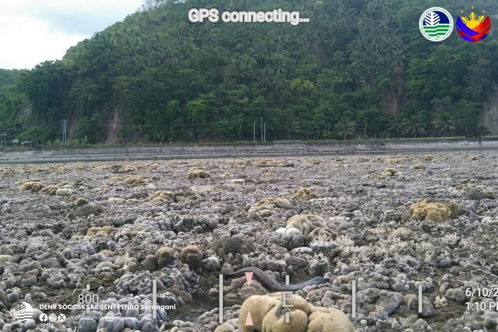
Environmental assessment teams sent to the affected areas discovered extensive stretches of exposed coral reefs and seagrass meadows.
Photographs released by authorities showed once-thriving coral formations baking under the sun. Fish, eels, clams, shells, and other marine creatures were found stranded on the newly exposed seabed.
For coastal residents, the sight was both fascinating and heartbreaking.
Many initially reported foul odors coming from the area and feared that toxic gases were being released. Experts later explained that the smell likely came from marine organisms dying after being suddenly exposed to air and heat.
DENR officials warned that the ecological consequences could be severe.
Coral reefs and seagrass beds serve as breeding grounds and shelters for countless marine species. They also support local fisheries and protect coastlines from erosion and storm surges.
When these habitats die, entire marine food chains can be disrupted.
Fisherfolk Fear Impact on Livelihoods
For fishing communities already recovering from the earthquake’s destruction, the loss of marine habitats adds another burden.
Many families in coastal Mindanao depend on fishing as their primary source of income. The health of coral reefs and seagrass ecosystems directly affects fish populations and future catches.
Residents worry that the damage could reduce fish stocks and further strain communities struggling to recover from damaged homes, disrupted livelihoods, and the loss of loved ones.
Government experts are continuing surveys to determine how much coastline and marine habitat have been affected.
Because of the vast area involved, officials say a full assessment may take weeks.
Nature’s Power on Display
Scientists note that coastal uplift is a natural consequence of major earthquakes, though events large enough to visibly alter shorelines are relatively uncommon.
In some cases, uplifted coastlines remain permanently elevated, creating entirely new landscapes and ecosystems.
For the people of southern Mindanao, the exposed seabed stands as a powerful reminder of the immense forces beneath the earth.
The earthquake did more than shake buildings and communities. It changed the very shape of the land and sea.
As survivors continue rebuilding their homes and lives, the transformed coastline serves as a visible marker of a disaster whose effects extend far beyond the immediate death toll.
The tragedy of the earthquake is being measured not only in lives lost and structures destroyed, but also in the silent disappearance of marine habitats that once thrived beneath the waves.

